

M.1 Connections
M.1.1 The scheme integrates well with its surroundings by reinforcing existing connections and creating accessible, inclusive new ones, linking to main routes, public pathways and public transport facilities.
M.1.2 Pedestrian links follow the shortest routes and desire lines.
M.1.3 A connected network of protected cycle tracks is provided to serve all parts of the development, and this leads directly to off-site routes.
M.2 Highway network
M.2.1 The street pattern forms perimeter blocks of optimum dimensions that results in land efficiency, with buildings contributing positively to the public realm.
M.2.2 There are no large perimeter blocks. When a block-dividing street is not a feasible option, wide, accessible, overviewed pedestrian-cycling links across large the block are provided, keeping walking distances under 100m per block.
M.2.3 The overall highway network is easy to navigate and to remember; its legibility makes it easy for pedestrians to create a mental map of the area.
M.3 Efficiency
M.3.1 There are no streets designed to worst-case scenario, with oversized and over engineered carriageways and turning radii (see technical details for street and corner dimensions).

M.3.2 Street patterns are regular, with straight carriageways that result in walkable, legible perimeter blocks. There are no curved streets (unless the topography requires this). There are no cul-de-sacs.

M.3.3 There are no deep perimeter blocks that lead to the creation of courtyards (unless flats are provided). Any mews arrangements include well designed public realm with brick or stone walls and no lightweight fences.

Cul-de-sac patterns are land hungry, highly inefficient and result in circa 40% of the land taken by highways. Research shows neighbours in these areas are less connected and in cities, these urban patterns are more difficult to police.

Perimeter block patterns are the most land efficient, have better definition between private and public spaces and prompt more neighbourhood relations and feel safer, better illuminated and natural surveillance is stronger.
M.4 Hierarchy
M.4.1 All streets are designed and classified according to the widths below and the technical details on this page.
M.4.2 The street pattern has a distinctive hierarchy with streets of different sizes and character. Streets are connected, forming a clear network, and each street is designed according to its function, scale, character and feel.

M.4.3 Any private streets proposed complies with the following:
Specifications are to adoptable standards (materials and dimensions)
The design follows either the Lane or Mews typology
Serve a maximum of 6 homes
Waste collection for the homes served is provided within the adopted highway network
Any turning heads are designed as per the Technical Details on this page
Provides pedestrian-cycling links to the highway network through the street

These are main connectors, streets where one expects to see buses, cyclists and heavier traffic. Example: Mansfield Road, Carrington and Gregory Boulevard, Forest Fields/Hyson Green.
Avenue: a broad road in a town or city, typically having trees at regular intervals along its sides. Boulevard: a wide street in a town or city, typically one lined with trees.

These are the type of streets one would see as distributors within neighbourhoods. Example: Robin Hood Way, The Meadows.
Main Street: the principal street of a town, traditionally the site of shops, banks, and other businesses; streets that might require a bus route in the future.
Residential Street: streets in residential areas that will never have bus services through, but that serve up to 50 dwellings.

These are quiet neighbourhood streets that bring people together. Example: Woodville Road, Sherwood.
Lane: a narrow road, especially in a quiet area.
Mews: a row or street of houses or flats that have been converted from stables or built to look like former stables; a group of stables, typically with rooms above, built round a yard or along an alley. Mews must not be dead ends; fully connected Mews are preferable but pedestrian/cycling connection only would be acceptable.
Private Street: one that is not adopted by Nottingham City Council’s Highways Authority.
M.5 Walkability
M.5.1 Crossings give priority to pedestrians with accessibility-friendly continuous level paving on 20mph streets, and are positioned to make walking routes shorter, easier and more amenable.
M.5.2 The radii, curvature, width and materials of roads and streets are designed to make the environment more walkable, with streets providing direct front access to homes for both pedestrians and cyclists.
M.5.3 Walking routes consider the needs of all, including children on bikes and scooters and people with mobility aid equipment. Benches are provided every 100m along public footways connecting with green/recreation areas.
M.6 Speed
M.6.1 Engineered traffic calming measures are only proposed for Primary Streets and through agreement with all the relevant departments of the City Council.
M.6.2 Streets are straight and naturally calmed with green and blue infrastructure, using nature to create a softer feel. Curving and/or curling a streets does not make it slower but it reduces land efficiency, making homes less affordable as a result.

M.6.3 Conventional streets (with kerbs and footways) are only proposed for Main Streets and Residential Streets. In residential-only environments, all other street types are designed with level surface and clear accessibility-friendly demarcation of footways.
M.7 Durability
M.7.1 Tarmac is specified for all corners and manoeuvring zones. Block paving is only used only in small amounts and in short, straight stretches. Block paving is not proposed for curves and corners.
M.7.2 Demarcations indicating zones (e.g. parking space, footway, etc.) are made with inset stone/pavers. There are no painted demarcations.
M.7.3 Streets adjacent to a green open space include knee railing to avoid parking on or driving onto greenery.
M.8 Services
M.8.1 The street network is designed with circuits for waste collection with ‘in’ and ‘out’ points with concealed bin storage in convenient locations along the circuit.
M.8.2 Any turning points are on adopted T junctions. Reversing tracking for these specifications has been submitted to demonstrate the design works and that it is not oversized.
M.8.3 Service runs and lamp posts are located in dedicated zones, easy to access for repairs and integrates in the design - not as an addition.
M.9 Greenery
M.9.1 Sustainable drainage and green infrastructure provision are considered from the outset - not as an afterthought. Green and blue infrastructure are combined and integrated to the street design. Street greenery is of significant impact, and is incorporated as part of the traffic calming and street design, not a result of poor street geometry or bad definition between public and private areas.
M9..2 All trees have adequate root protection and sufficient root space (at least equal to their canopy potential). Trees counted for canopy increase and/or Urban Greening Factor (UGF) are planted in the public realm or in shared/communal areas; not in private gardens (front or rear).
M.9.3 Verges in Primary Streets are at least 5m wide to become adopted by the Parks and Open Spaces department - not by Highways (see dimensions for Primary Streets; M.4a).
M.10 Parking
M.10.1 DISTRIBUTION - A car parking strategy indicates the modality distribution; in other words, the percentage - and number - of parking types is clearly defined and balanced; one type of parking does not dominate over others.
M.10.2 FRONT PARKING - There are no more than six consecutive front parking spaces; alternate greenery was used to mitigate the impact of front parking. Boundary walls and other installations adjacent to front parking are 500mm high or less.
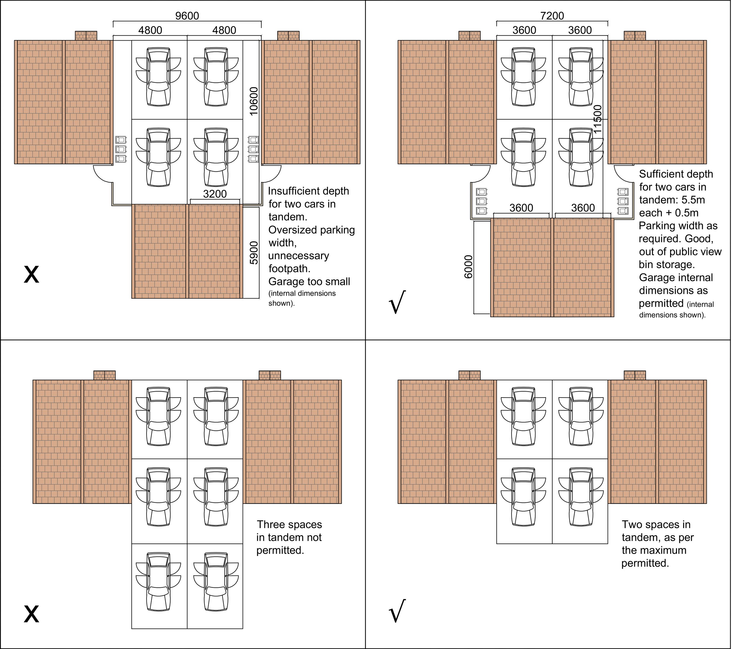
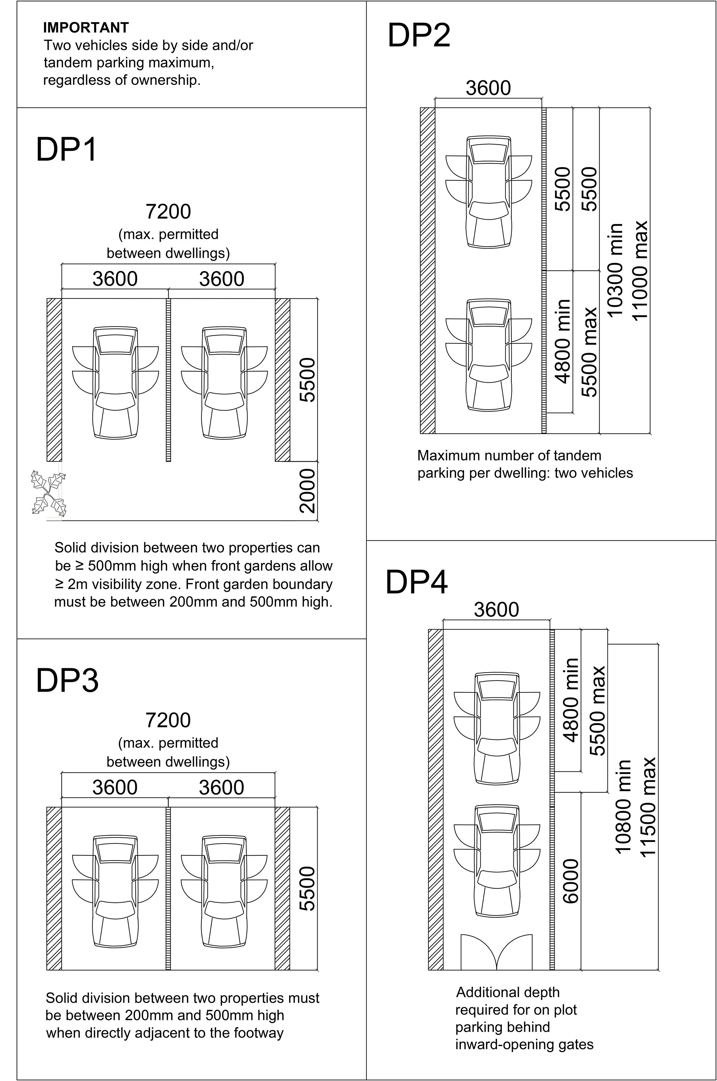
M.10.3 SIDE DRIVEWAY PARKING - There are no more than two consecutive driveway parking spaces (side by side), including in situations when parking provision is for two different dwellings (e.g. semi-detached homes), in which case, a solid boundary demarcates the end of each property (e.g. railing). There are no more than two parking spaces in tandem.
M.10.4 ON-PLOT PARKING - Spaces provided at the side or rear of dwellings are located inside the plot and contained within the boundaries of the property. An inward-opening gate is provided. There is no rear or side parking provision outside the property boundary/walls.

M.10.5 ON-STREET PARKING - On-street parking is proposed along one side of the road only (not along both carriageways). There are no more than three consecutive on-street parking spaces at any point. If more than three are proposed for one street, out-builds for trees/planters have been used to mitigate car dominance in the street scene. When necessary, Traffic Regulation Orders are agreed with the Highways Authority to create ‘residents only’ parking areas.
M.10.6 COURTYARD PARKING - Clustered parking types are kept to an absolute minimum. If provided, it is well overlooked, directly connected to homes and secured (for example, with gates). There are no wooden fences facing courtyard parking, all boundaries are brickwork walls (see C.9 Built Form).
M.10.7 GARAGES - Parking on garages is not counted as parking provision. Garages are well positioned so that they do not dominate the street scene. There are no more than three consecutive dwellings with front garage. There are no instances of garages fronting each other (on both sides of the street).
M.10.8 FUTURE PROFING - All new homes with parking on plot (front, side driveway or rear) provide an in situ electric vehicle charger. If a car-share scheme is included in the transport strategy, car-share parking with electric vehicle charging points is provided every 200m or less in all directions. If there are streets with single carriageway zones, or when on-street parking prevents vehicles to pull out without blocking the road, lay-bys are provided for delivery vehicles and potential drone/robot deliveries.
M.10.9 MATERIALS - durable, permeable driveway materials like permeable paving is specified all new and upgraded front parking zones within private properties. All private streets are proposed to adoptable materials specifications.
M.10.10 PARKING DIMENSIONS - All proposed parking meets the minimum parking dimensions for Nottingham City.
pARKING TECHNICAL DETAILS
Dimensions

Group Parking
Not Permitted


Vision
Nottingham will be walkable, accessible and inclusive. Streets and parking spaces will be convenient, land-efficient and durable. Cars will not dominate the street scene; greenery and sustainable drainage will be incorporated to achieve significant impact, and not as a token.
We support a people-first design ethos and therefore, streets should not be designed primarily with vehicles in mind. In Nottingham, we see streets as PLACES, vehicles happen to be able to circulate through them.
Nottingham City requires all developments to consider cycling lanes and sustainable drainage measures (see the Drainage page) from early stages in the design concept. These must be integrated into the street design and the adoption strategy must be discussed with the relevant specialist officers.
Nottingham only requires 1 to 1.5 parking spaces per dwelling due to the exceptional public transport system in the city. Developers often prefer offering more parking spaces for 3-5 bedroom homes in out of town locations, therefore, a maximum of two spaces per dwelling for large homes could be acceptable upon liaison with the case officer.
The DQF makes it clear that car-dominated streets are not acceptable and when necessary, applicants will be strongly advised to change their designs or face significant delays and very possibly planning refusal.
COURTYARDS
Parking in court yards is strongly discouraged and will only be considered acceptable to serve flats (one car per dwelling) and when the parking area is not adjacent or visible from the street scene.
ELECTRIC VEHICLES
Nottingham City Council requires at least one electric vehicle charging point for every parking on plot or curtilage.


CYCLING INFRASTRUCTURE
Active Travel England also provide advice and guidance on best practice when designing and implementing streets to ensure they are of the highest quality for walking and cycling. The Council when designing new infrastructure is required to refer to Active Travel England’s design guidance document LTN1/20. This design criteria will be referred to when assessing applications and we advise you review the documents and the guidance provided in the Active Travel England’s planning application assessment tool.
Please note that Active Travel England are a statutory consultee on all major planning applications or developments equal to or exceeding 150 housing units, 7,500 m2 of floorspace or an area of 5 hectares.
Cycle Infrastructure Design (LTN1/20)
Active Travel England: planning application assessment toolkit
TECHNICAL DETAILS
Avenues and Boulevards
For tree-lined avenues and boulevards, tree adoption is by Parks and Open Spaces - not by the highways authority - and it includes the adoption of a 5m wide (minimum) verge.


Main Streets


Residential Streets


Lanes


Mews


Private Streets

NON-COMPLIANT turning head showing on the left. COMPLIANT solutions showing on the right.